
|
I had just gone to bed at 02.00 after recharging all the camera gear from yesterday's chase at Mullaghmore but before I did I checked our Ireland/NI storm chasers facebook page and there was a convective outlook issued by Owain Rice for the following day and it looked like it would be the same target areas again so another long drive looked to be on the cards. The next morning I was up early making preparations, it was a Sunday so Roisin was off and this time she would be joining Rhua and I, she was game for a road trip, nice scenery, and hopefully something cool from nature.
Roisin had been listening to me going on about great storms in recent days that she was starting to feel that she was missing out, she knows when I get obsessive and go on about something then it has to be good. I was really hoping we would get a repeat of yesterday with prolific thunder and lightning so Roisin could get a taste of what proper storms were like. The set-up was similar to June 17th, a very warm and humid air mass, gentle SEly flow, 1700jkg/CAPE, LIs -5, -40c tops, we would have no warm front this time for lift so we would be replying strictly on solar heating and convergence zones with upslope help from higher terrain and the models indicated that all these would be present to some degree depending on the location. Owain had an amber box around the area of interest and CW had issued a severe thunderstorm box.
The morning of June 18th was very warm and sunny, clear blue skies, and towers already growing, the humidity was strong again with that wet feeling to the air on your skin, not comfortable at all however I loved it, it meant fuel for storms. We packed the camera gear, food supplies, four flasks of water, a cooler box, sandwiches, tea, and Rhua's dinner, then stopped off at a cafe in Cookstown, a coconut latte for Roisin and summer fruits smoothie for me, then we hit the road west, west was best yet again.
It was a matter of choosing a target area again, the Met Office had issued a yellow thunderstorm warning for west Ulster over Omagh, Fermanagh, Derry/Foyle areas. It would be very handy if something did fire there as it would save us a long drive but I wasn't buying the Met's view on things. West would be much better, into the deeper CAPE, the models wanted more in the way of precip there too, also colder tops and sea breeze convergence zones could make the difference, my targets were Co. Sligo or Co. Donegal, GFS in particular liked those areas and it had been spot on over the last couple of days. As we drove along the hot Omagh road with AC on and windows down to combat the growing heat I looked out the window and saw a huge cell which had erupted from nothing about five miles east of Omagh, it had four well formed crisp updraughts and a well defined dark base, it almost stopped us in our tracks. I really thought it was going to turn into a storm at noon or drop a funnel but my instincts told me not to get lured by it and remain committed to our original target area, sometimes in storm chasing you have to be single minded and just make definitive decisions and stick with them.
We took a break at a picnic area in proximity to the world famous lakes in Co. Fermanagh. We had lunch, kept hydrated, and watched towering cumulus get more and more agitated, the atmosphere looked very capped to me and there was no visual sign of trouble from the sky but I knew this wouldn't last, it would break sometime, likely later on. Back on the road we passed through Belleek, over the border, and headed straight for Mullaghmore. It had been years since Roisin had been there to see a storm so she was delighted to be back, especially when your eyes lock onto Classiebawn Castle for the first time. We arrived at our location, being a Sunday it was busy with visitors, so we walked out onto the grass near the edge of the cliff and sat down to enjoy the scenery, we had plenty of time to kill.
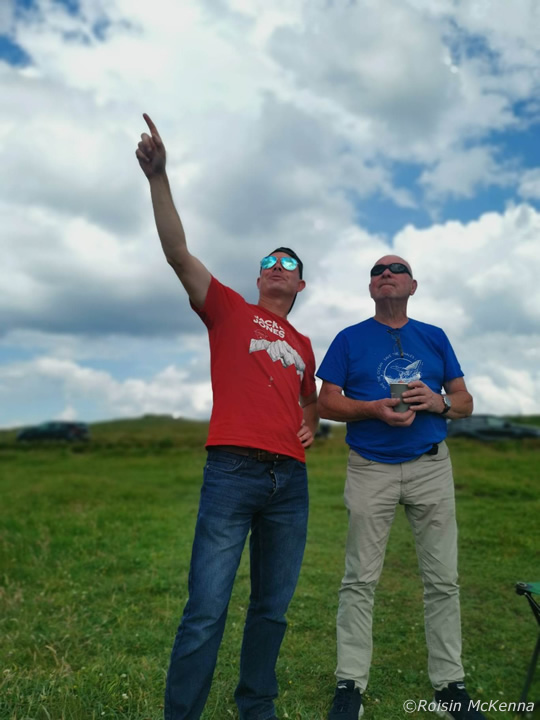 |
Then I got a call from my Dad, it turned out he was at Mullaghmore too with his partner Colleen, they where just around the corner and were looking for storms too so we all met up to sky watch together, thanks to Roisin for taking this image of Dad and I watching convection. Unlike the previous day when we arrived when it was cloudy and we were thrown into the action fairly quickly, this day was the polar opposite. To the untrained eye it was the perfect day with blazing sunshine, high humidity and beautiful white cu and towering cu bubbling frantically then rolling over like an ocean wave below an invisible capping inversion. I said this would be a long wait but when the cap broke storms would develop rapidly.
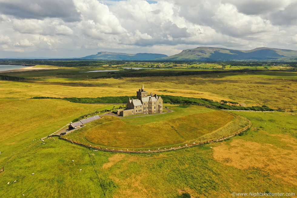 |
We all sat on the grass to take in the view and watch over the sea, it was very warm, almost stifling sitting in the grass. Since we had time to kill I decided to get the drone in the air to once again film Classiebawn Castle, I'm not often in this part of the country - unless there are storms - so I decided it would be a shame not to make the most of it and acquire new content and stock footage, especially when the weather was perfect. I gave the Mavic 3 Classic a rest today and instead used my trusty Mavic 2 Pro, I filmed several sequences and captured new images, this is the view which not many others get to see showing the front of the castle, what a fantastic landscape this is.
A couple of hours later the sky was still behaving itself, the cap was holding strong however we did notice the towers were getting bigger, it felt like the atmosphere was getting closer to releasing all the instability which had been brewing all day. We managed to get wifi and check radar, I was momentarily afraid it would show nothing but this anxiety passed in a second, there were big storms coming up!. Radar revealed a very active cluster to the S and SE of us slowly moving up with regular sparks, and a second area of interest was sparking far out over the ocean to our SW/W, sferics showed the midlands and western side of Ireland covered with c-gs, storms had been battering the country for hours, if they continued moving N/NW they would be with us within the hour.
 |
We did a competition to see who would be the first to hear thunder, Colleen won moments later when the first distant rumble boomed across the sea from storms that where many miles away, we could see their bases and precip getting stronger, however they would never approach us, staying over the Atlantic. We listened to sporadic thunder for some time getting louder but now our attention was turning to that area of interest inland. By early evening the cap broke at our location, we where still laying on the warm grass watching the skies, Dad and I noticed that convection was getting quite intense behind us inland to the east, for a while we contemplated moving 10 miles east to get in a better position but then decided to stay put as we had a good side-on view of the cells anyway.
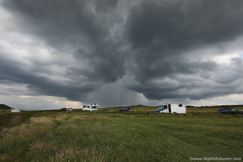
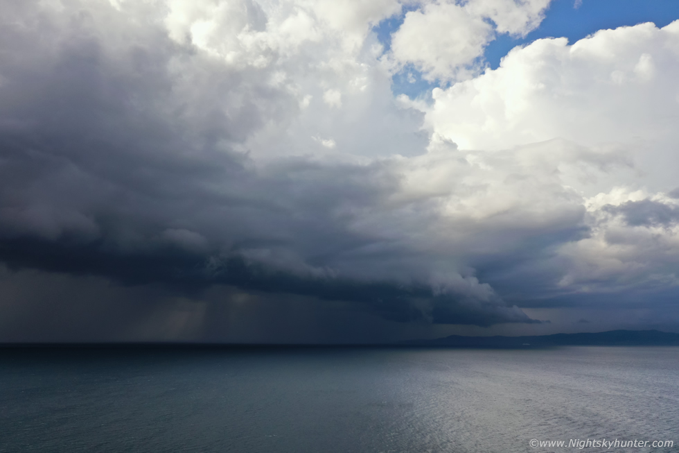
We watched one tower grow tall, develop cauliflower knuckles on the updraught then start producing precip. Ten minutes later a loud rumble of thunder broke the tranquility of the day, a thunderstorm was born. 15mm wide angle DSLR image of that isolated storm which was red and white on radar, it was rumbling sporadically while moving NW, it looked to be heading for Donegal. The precip core had a hint of green colour and it looked quite cool as it passed behind the holiday camper vans. Amazing how compact that core was, completely dry either side but judging by the radar there was likely flash flooding going on under there, you literally could walk in and out of the core, wet, dry, wet, dry, such is the bizarre nature of thunderstorm cells. There was a short-lived rain free base which we monitored for funnels then the cell moved out to sea.
At this stage Dad and Colleen decided to head home, now Roisin and Rhua and I decided to hold out for a while longer as things were just getting started. I noticed the visibility was greatly improved compared to yesterday so this I was grateful for, we could now see the cells better. I honestly had seen that much lightning the previous day that my mind was now on getting structure, could this third trip to Mullaghmore produce?
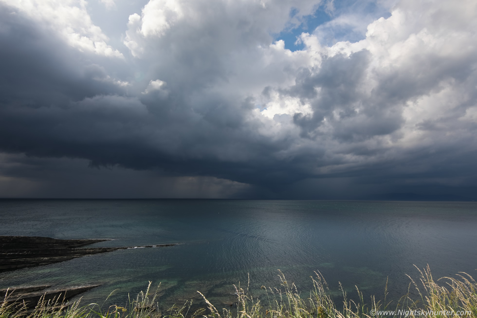 |
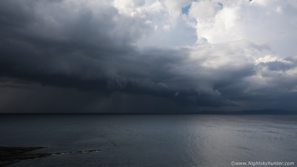
Roisin and I followed the curved road which followed the Mullaghmore coastline and pulled into a lay by which offered a great view across the sea to Donegal facing SW/W and during that drive which only lasted a few minutes the sky had completed evolved in impressive fashion. Two thunderstorms were rumbling over the sea, where the heck had those come from? I had seen some very robust towers behind the castle when we left, those must have moved over the sea and exploded within minutes. Roisin was even impressed with the view so we got out quickly and began taking images, Roisin was shooting with her phone while I set up the DSLR at 15mm and began a time lapse, this was one of the early DSLR stills showing the growing storm with long tilted base, rumbles were coming from the left and right.
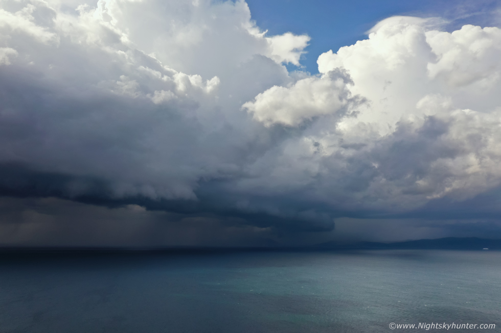 |
Content knowing the DSLR was shooting I got the Mavic 2 Pro drone in the air and began filming video and shooting stills. We now had two very large cells trekking over the sea, the lead cell was making landfall over W. Donegal, meanwhile the closer cell was forming a shelf cloud, I was getting my structure, Mullaghmore had produced again for the third time, the trip was already worth it at this point. We heard regular rumbles from both storms, again all lightning was in-cloud and high up within the towers, the Donegal cell even had a Pileus Cap for a period.
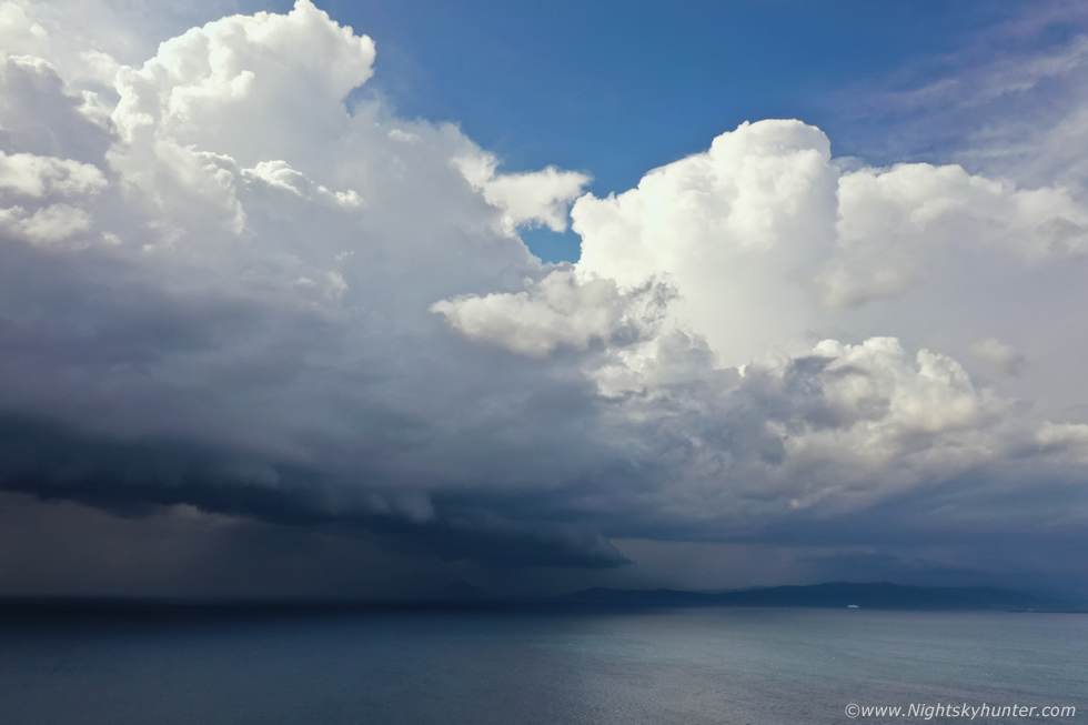 |
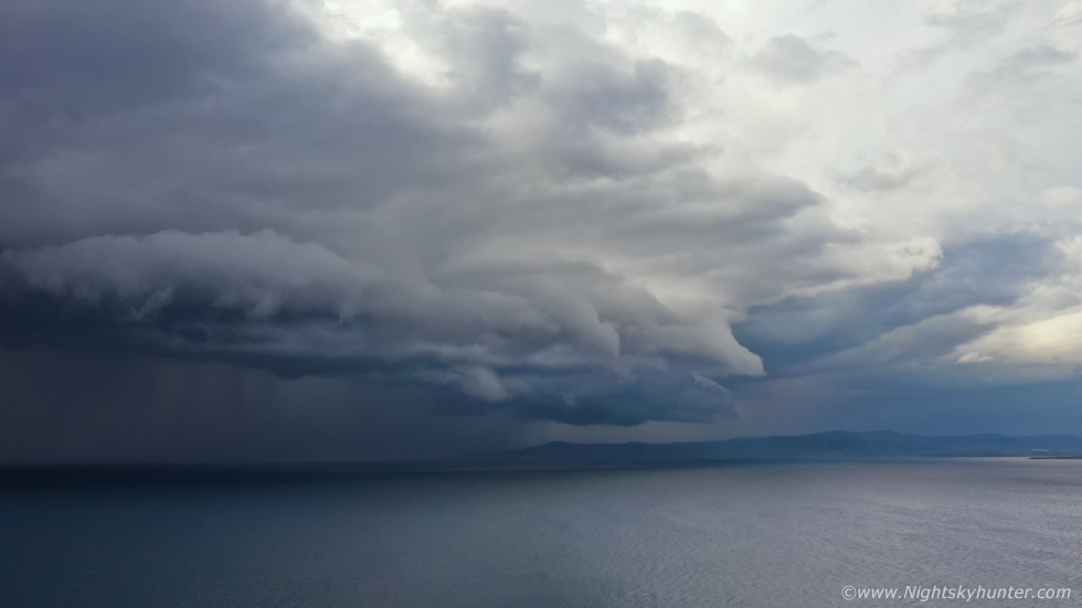
The drone was getting a work out again, hovering 80m in altitude free from any horizon obstructions, both storms in the same field was quite cool, you can make out a cruise ship in the distance which had just left Killybegs. The shelf cloud was getting more solid and surging across the sea closer to us, it was still warm and humid, no sign of the outflow yet.
 |
People had gathered to watch the storms, when they rumbled it got a mixed reaction, some stood and watched with fascination while others hid inside their cars.
 |
I was very happy with this scene, I wanted mean cloud structure and I got it and getting it over a clean flat foreground like an ocean was a bonus, this way the storm does all the talking in the images. This one was 15mm wide angle with the DSLR so this is a massive field of view. Roisin saw a nice c-g hit the ocean to the left of frame. I was in my element checking DSLR, flying the drone, buzzing with excitement and likely talking out loud, probably cursing a few times which I tend to do when I get really excited by nature.
 |
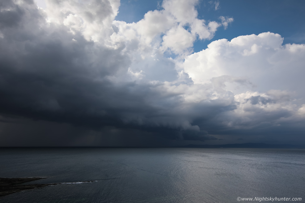
The warm humid air was suddenly replaced by a lovely refreshing cool breeze, the outflow from the storm had made it across the water and arrived onshore, it wasn't severe or blustery or annoying in any way, it was just refreshing and welcome to everyone.
 |
The storm became entirely outflow dominant and formed a lot of mean looking scud along the gust front, I heard some chatter from people beside me saying it looked like a tornado was forming. Even though some of those clouds looked smooth and tubular they were not rotating, it was the storm's outflow cold air undercutting the clouds and forming those shapes, these are 'scud' however they can often look very dramatic.
The storm hit and it rained for some time, the radar looked fairly quiet behind these cells so feeling content with what we had captured Roisin and I decided to call it a success and begin the drive back home. The entire trip back was in glorious sunshine, yet to the NW impressive updraughts continued to go up for hours over Donegal and the adjacent sea, I reckoned someone was getting a good show under those, GFS had been rite again. By the time we got back to Cookstown it was 20.00, it was nice to get back at a more reasonable time and get a chance to chill out for a few hours.
Cameras and drone were back on the chargers, footage and images downloaded onto the PC and external hard drive, I edited one of these images to post on social media but there was little time for relaxing as it looked like yet another chase day tomorrow, I couldn't believe it, this was the season which keeps on giving. The potential looked good and I decided I would study the parameters in the morning, however at a casual glance I underestimated the potential for little did I know it then but the following day would produce the most beautiful thunderstorm convection of my entire life!
Chase vlog covering the outlook and drone footage and DSLR time lapse of the Mullaghmore and Donegal cells over the ocean. Thanks very much reading and make sure to check out the next chase report which will no doubt be the finest day of this remarkable season.
Martin McKenna
